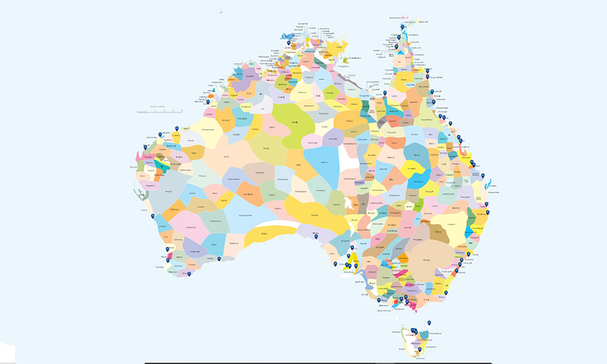
PORTS Australia has launched an online resource that locates ports on an Indigenous map of Australia. It is to help ports acknowledge the traditional custodians of the land on which they operate.
The map will be accompanied by information on Ports Australia’s sustainability hub showing how ports are taking reconciliation action or engaging with Aboriginal and Torres Strait Islander communities.
Ports Australia said the country’s ports are located in areas rich with the history and culture lived by the traditional custodians of the land.
“It’s important we identify the partnerships between ports and First Nation’s peoples and consider how we can empower one another to do more as an industry,” the ports body said.
“Ports taking on reconciliation action and engaging with Traditional Owners is a critical part of business on an acute port and local community level, but also on a far greater scale, contributing to the growth of unity between Aboriginal and Torres Strait Islander peoples and non-Indigenous peoples across Australia.”
Ports Australia acknowledged the work of Scarlett Cheesman, who interned with Ports Australia in 2021, bringing with her a wealth of knowledge from her studies helping to drive the development of this project.
Ports Australia CEO Mike Gallacher spoke about the origins and meaning behind the map.
“A major focus of Ports Australia for a number of years now has been understanding and sharing the sustainable practice and planning mechanisms of our ports … this project merely directs that focus closer towards reconciliation action and acknowledgment of traditional owners,” he said.
“It’s important we share what we’re doing right as individual businesses and an industry which inevitably informs and empowers us to do more for the betterment of the sector and nation as a whole.
“Most importantly, this map provides one central location where we can acknowledge the traditional custodians of the land on which our ports do their business every day,” Mr Gallacher said.
Ports Australia based the design of the map on the work of David R Horton for the Australian Institute of Aboriginal and Torres Strait Islander Studies. The map attempts to represent the language, social, or nation groups of Indigenous Australia, and the boundaries are not intended to be exact.
Anyone can view the interactive map here.

