PORTS on the Queensland coast have closed as Cyclone Jasper tracks toward the state’s north.
The regional harbour master for the ports of Cairns, Mourilyan, Port Douglas, Cooktown and Cape Flattery announced a red alert for the ports at 0900 AEST on Tuesday 12 December.
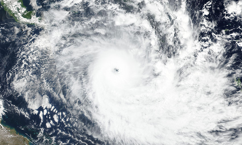
Tropical Cyclone Jasper was still moving westward toward the coast on Tuesday morning as a category 1 system, but the Bureau of Meteorology warned it could re-intensify before crossing the coast, likely as a category 2 system on Wednesday.
Ports North chief executive officer Richard Stevenson said the harbour master placed the affected ports on orange alert on Monday, and all vessels at the ports were moving to safer anchorage areas.
“The cyclone’s movements remain uncertain, but we note that the regional harbour master has upgraded the alert to Red at 0900 this morning which means that all ports will be closed,” Mr Stevenson said.
“We have activated our Extreme Weather Event Management group and we continue to prepare our ports in accordance with our cyclone procedures.”
Maritime Safety Queensland general manager Kell Dillon said MSQ was monitoring the track of Tropical Cyclone Jasper in the Coral Sea.
“Maritime Safety Queensland’s primary role during and after a tropical cyclone event is to ensure the safety of all maritime traffic in the affected area and to respond to any maritime emergencies,” he told DCN.
“For Queensland’s northern ports, MSQ’s safety arrangements are overseen by regional harbour masters in Cairns, Townsville and Mackay, who work closely with the North Queensland Bulk Ports Corporation, Ports North and Port of Townsville to ensure that shipping is well informed about the approach of cyclones and what to do.
“For the ports of Cairns, Port Douglas, Mourilyan, Cooktown and Cape Flattery, all ships and superyachts have departed to sea for cyclone avoidance.
“The commercial domestic fleet such as reef tourism vessels, fishing vessels and also recreational craft have now moved to protected creeks and cyclone moorings as per the Extreme Weather Event plans.”
Mr Dillon said MSQ’s Extreme Weather Event Contingency Plans typically describe the key actions and management of ports during and after a tropical cyclone.
He said there are two key markers when assessing and reacting to a tropical cyclone. The first marker, Cyclone Watch, occurs 48 hours before landfall. During this phase, all ships are to prepare to depart the port and proceed to sea.
And the second marker, Cyclone Warning, comes 24 hours before landfall. During this phase, all ships depart the port and proceed to sea.
“This is ordinarily when MSQ will be in final planning for closing the port,” Mr Dillon said.
He said there will be a recovery phase after the cyclone has made landfall, involving damage assessments within the port, focusing especially on port infrastructure and the port channels.
“Once the recovery phase is complete (which may vary between a few hours and a few days), ships will be permitted to return to the ports,” Mr Dillon said.
MSQ advised the maritime community to refer to the Bureau of Meteorology’s website and the online MSQ dashboard for up-to-date information.


