MARITIME Safety Queensland, port authorities and regional harbour masters are closely watching a tropical low in the Coral Sea the Bureau of Meteorology expect to develop into a Category 3 cyclone.
According to a Notice to Industry issued by agents GAC, due to the large number of vessels (56) anchored at Hay Point and Mackay the Regional Harbour Master decided to begin the orderly evacuation of vessels with no berthing prospects at first light today. Last departures from Hay Point and Dalrymple Bay coal terminals were scheduled for this afternoon, while Abbot Point’s last vessel sailed this morning.
Possible closure of the port of Townsville was under review this afternoon. The operators of round-the-world cruiser Vasco de Gama have already cancelled the ship’s planned Wednesday call.
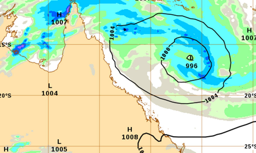
According to the BOM’s tropical cyclone advice issued at 11.10 EST this morning, the watch zone extends from Cairns to St Lawrence (not including Cairns), including Townsville, Mackay and the Whitsunday Islands.
The slow-moving tropical low, with sustained winds near the centre of 65 kph and gusts to 95 kph was located in the Coral Sea within 35 kms of 16.3 degrees South 153.7 degrees East, estimated to be 800 km east northeast of Townsville and 395 km east of Willis Island.
The Bureau said the low is expected to become a tropical cyclone overnight tonight (Tuesday) or early Wednesday and to track southwest, towards the Queensland coast, over the next few days as it intensifies. The system is likely to cross the Queensland coast late Thursday between Cardwell and Airlie Beach as a Category 3 system.
In the longer term, the system is likely to track inland and south as a deep tropical low bringing heavy to intense rain to parts of central, western and southern Queensland. As the system approaches and crosses the coast, a storm tide is expected between Townsville and Mackay.