
UPDATE: All Pilbara Ports open in wake of Cyclone Mitchell
-
Posted by Allen Newton
- |
-
09 February, 2026
ALL PILBARA Ports are now open following the passage of Severe Tropical Cyclone Mitchell which forced widespread shutdowns across Western Australia’s Pilbara coast over the weekend.
Majorexport ports were closed and mining operations faced significant disruption.
Operations resumed at the Port of Port Hedland on Sunday and the Ports of Ashburton, Cape Preston West, Dampier and Varanus Island followed suit at 8am AWST on Monday.
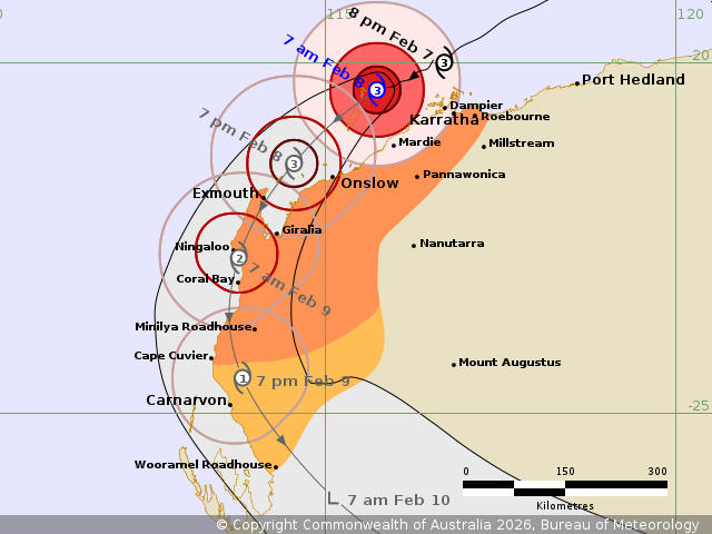
The Bureau of Meteorology said at 11 am the cyclone had become a category 1 storm and was heading down the Gascoyne coast.
A warning zone was in place from Coral Bay to Overlander Roadhouse, including Carnarvon and Denham, and extending through the western Gascoyne.
Awarning for Ningaloo, and inland parts of the western Gascoyne including Gascoyne Junction had been cancelled.
The category 1 cyclone had sustained winds near the centre of 85 kilometres perhour with wind gusts to 120 kilometres per hour.
It was located within 20 kilometres of 23.8 degrees South, 113.3 degrees East, 130kilometres north northwest of Carnarvon and 85 kilometres southwest of Coral Bay and was moving south southwest at 19 kilometres per hour.
“Mitchell is expected to maintain category 1 strength until it crosses the Gascoyne Coast later on Monday, then moves inland to the southeast and quickly weakens,” BOM said.
It warned that gales with damaging wind gusts to 120 km/h are occurring about coastal areas from Coral Bay to south of Cape Cuvier.
“During Monday, gales are likely to extend further south through the Gascoyne coast, developing over Carnarvon in the afternoon and possibly to Denham, Wooramel and Overlander Roadhouse during the evening.
“Isolated heavy to intense rainfall which may lead to flash flooding is possible over the west Pilbara coast, extending to the west Gascoyne region during Monday and continuing overnight into Tuesday.
“Abnormally high tides are expected to rise above the normal high tide mark along the Gascoyne coast including at Coral Bay on Monday afternoon's high tide causing flooding of low-lying coastal areas.
“Abnormally high tides are expected at Carnarvon on Monday afternoon's high tide and possibly further south to Denham overnight Monday.
“A severe weather warning is also current for parts of the Gascoyne, Central West and Central Wheatbelt.”
Pilbara Ports Authority had cleared all its ports on Saturday ahead of destructive winds and abnormally high tides.
All vessel movements were ceased, anchorages were cleared and offshore support vessels were sheltering or repositioning.
Mining operations at Rio Tinto, Woodside, FMG and Chevron were impacted with workforce movement and site access hindered.